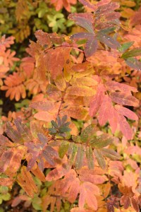
Ah, the mythical larches. I hadn’t heard of these magical trees until I started following various hiking forums several years ago. Every September and October, reports started coming out about people going to great lengths to see them. I didn’t pay much attention for a few years, then I started to view those TRs wistfully, thinking that maybe I should try to get in on the fun, too. Larches are special because they are conifers that lose their needles, turning a bright, lemony gold before dropping them. They turn golden at the same time that the blueberry leaves are turning crimson, and on a sunny autumn day, they glow like candles on the mountainsides.

The tricky part is that they don’t grow just anywhere. The alpine larch, Larix lyalii, grows only at high elevations in the northern Cascades and the Rocky Mountains. (Western larch, Larix occidentalis, grow at lower elevations east of the Cascade crest.) They grow generally between 5800 and 9900 feet, and tolerate poor soils in areas of granite or quartzite talus. Since they grow so high in elevation, it takes a bit of a drive and longer hikes to get to places where you can see them up close. Thankfully, there are a few larch hikes in the North Cascades that are kid-friendly.
The past couple of years, we’ve had iffy weather during the window of larch viewing, and our busy schedules have made it difficult to be picky about days we could travel up to see them. (See my reports for Longs Pass, Blue Lake, and Cutthroat Lake.) This year, we hit the weather jackpot, and had a day off during a sunny stretch. We picked a difficult hike; the kids are old enough now that I feel I can push them a bit, and they were willing to try a longer hike for the reward of fall colors. The Heather and Maple Pass trail starts at Rainy Pass on Highway 20, a few miles west of Washington Pass. The large parking lot was only about half full on the Friday morning when we pulled up around 10:45. (Even though I tried to leave earlier, this was the best we could do for a starting time.) It was pretty chilly at the trailhead, and we bundled up and rushed to get ready so we could warm up by hiking.
We chose to do the loop counter-clockwise. The trail leaves the parking lot near the large trailhead sign (take the dirt trail to the right) and gently begins climbing through forest of subalpine fir and other mixed conifers and undergrowth.


Somewhere around 0.75 miles, the trail traverses a talus slope, with the first brilliant colors and sounds of pikas echoing off the rocks.


Shortly after that section, at around 1.25 miles, the trail branches off to the left for Lake Ann. We didn’t go to the lake; it adds another 0.3 miles each way to an already long hike, but younger children might be content to stop there and turn around. You can see larches on the hillsides around the lake; the colors are beautiful from there without going higher.

We made our first stop for snacks before beginning the ascent up the side of the bowl to Heather Pass. This part of the trail starts to get rocky in sections, and there are 3 or 4 switchbacks as you get close to the pass.


We enjoyed catching our breath while taking photos of the lake down below, with the sunshine illuminating the water and the blazing colors of the foliage around us.

During this section we found the tiniest frog in the dry dirt, high above the lake.

It was barely bigger than my fingernail. Up above us, fog rolled in over Heather Pass and dissipated before sinking down.


Also during this time, Gabe got so far ahead of us that we couldn’t see him or hear him any more. I was getting a bit worried, because I expected him to have noticed that we weren’t behind him, and to stop and wait. Thankfully, he did wait at the junction of trails at Heather Pass. But I had some stern words for him about getting too far separated from us. He chafes against being hampered by the slow pace Annika and I keep. But I really need him to learn that as part of a team, we stick together, and bad things can happen when we get separated. I think there is something particular about teen boys (in my limited experience so far) that cause them to be thick-headed about this principle.
At any rate, Heather Pass exceeded my expectations for beauty.


We walked to the north on the side trail (being careful to stay on the trail; there are many areas roped off for restoration along here.) We ate our lunches there on the pass, Corteo Peak hiding behind the fog rolling through. Soon the clouds melted away, and the sun illuminated all the foliage.


Heavy dew glittered on the larch needles like diamonds. We could see over to Lewis Lake, Black Peak, and the mountains to the northwest. It is such a unique landscape of rock and plants. At this point I texted Aaron to let him know our progress, but while waiting for a possible return text, my PLB disconnected mysteriously from my phone and I couldn’t get it to reconnect. The one thing I didn’t try was rebooting my phone, because I didn’t know if I would ruin the tracking I was doing with my GPS app. I just hoped if I needed the device later in the day, I would be able to get it to work.
Heather Pass would be a fine place to stop and turn around. You’ll get your larch and fall color fix (and wildflowers in the summer, I hear!)

and skip any of the scary exposure for younger children. Annika would have been fine turning around here. But Gabe and I wanted to complete the loop, and she was willing, too. So we went back to the main trail, and continued upward toward Maple Pass.


This section of the trail felt magical. So much color shining all around us, blueberries ripe for the eating, a new view with every twist and turn of the path.


Higher and higher we climbed, through patches of larches, rocks, blueberries, heather, and one dizzying section far above Lake Ann.


We found another frog (or toad?) up in the rocks of this part of the trail. Gabe did much better sticking close to us, to my relief.


We reached the National Park boundary and took some photos out to the southwest. Snowy peaks shone in the afternoon light in the distance. I was so full of gratitude to have been able to make it up to such a spectacular location with the kids.


We were not looking forward to more climbing, as we could see the trail ascending even more from Maple Pass to a ridge on the side of Frisco Mountain.


We stopped for a breather on the way up, and refilled our water bladders with the extra water I had brought. (The only water sources once you leave Lake Ann are a couple of shallow tarns that may or may not be available.) I urged us onward with the promise of one more snack break at the top of the ridge before heading down the last few miles back to the car. It was cold and windy at the top of the ridge, and we layered up while we fueled up.

We could see the trail below us, switchbacking steeply through talus slopes interspersed with red blueberry bushes. It was moving into the evening hours, and the shadows were growing longer. The trail on this back portion of the loop descends steeply and unremittingly along narrow ridges and through patches of larch and evergreen conifers.


In my tired state, there were a few spots along this section that really made me uncomfortable. That is rare for me while hiking, and I’m not sure if I went back fresh and rested, would I be as concerned? The trail in sections felt very exposed, and it seemed if someone tripped or fell, they would roll all the way down to Rainy Lake or tumble off a cliff. Maybe it’s not so scary feeling hiking up this part? I’m not sure, but I was very glad to get back in the forest and a slightly gentler grade.

It was getting close to sunset, and every time we came to a view of the valley, the highway still looked so far below us.


My feet were hurting a lot, and my legs were getting pretty tired from the descent. We trudged onward, though, and as we got closer to the bottom, it was getting quite dark under the trees. In the interest of safety, Annika and I pulled out our headlamps so we wouldn’t trip on any rocks. The last half mile of the trail is on the paved Rainy Lake Trail, so it goes much faster. We were relieved to reach the car around 7:30 pm, when it was truly getting dark. We unloaded quickly, ate some yogurts, and headed home. I had offered to cook the kids some dinner there, but they didn’t want to wait around in the dark at the trailhead while I did that, so we just ate our snacks until we got to civilization.

If You Go:
Drive Highway 20 east through Marblemount and Newhalem, until you get to Rainy Pass. There is a large trailhead off to the right, with privies. If that parking lot is full, there is another parking area on the other side of the highway. You’ll need your NWForest Pass to park. The loop can be completed either direction; if you go counter-clockwise, you’ll reach the interesting parts sooner and have a gentler climb. Be sure to start early; it takes at least 3 hours to drive there from the Seattle area (usually it takes me 3 1/2 hours). The North Cascades Highway closes in late autumn when the snows cause it to be unsafe, and opens again in mid-spring. The best time to view the larches is generally the last week in September through the first week or two in October, depending on weather conditions.

Leave a Reply